This is an example of a HTML caption with a link.

Artículos mas leídos

    Xcambó

    X´cambó es vegetación y arqueología de un mundo escondido

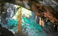
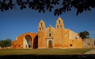
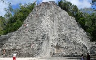
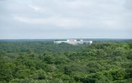
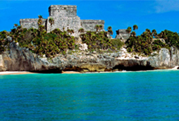
    Xcambó (X'Cambó) es un yacimiento arqueológico que se encuentra ubicado, en el municipio de Dzemul en el estado mexicano de Yucatán. Es considerada por los expertos como una de las zonas de mayor extensión en la costa peninsular y con edificios de grandes dimensiones. Se asienta sobre el bosque húmedo de la ciénaga, a sólo 2 kilómetros de la costa del Golfo de México, en el norte de la península, aproximadamente 40 km al noreste de la ciudad de Mérida, capital del estado.

    Mas información

    La ciudad precolombina de Xcambó se ha definido como un puerto que fue importante para el desarrollo comercial y salinero de su época, principalmente durante el periodo clásico temprano.
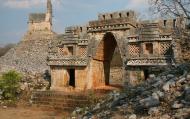
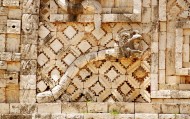
    En el yacimiento se encuentra una plataforma llamada el Templo de la Cruz, basamento escalonado con una cruz en su parte superior. También otro basamento en cuya parte superior está el denominado el Templo de los Sacrificios, así como un cierto número de enterramientos que al descubrirse se encontraron con ofrendas ricas en cerámica foránea (polícromos de Guatemala y figurillas femeninas de la isla de Jaina).

    Ubicación y Actividades

    Dzemul.,Yucatan. Sitio arqueológico.

    Precio

    El costo de entrada es de $31 (está sujeto a cambio).

    Como llegar

    Para llegar a este sitio desde Mérida tome la carretera a Progreso (núm. 261), entrando a Progreso notará la pista de remo y canotaje, poco después se encuentra un entronque doble a la derecha y seguir por la carretera estatal núm. 27 a Telchac Puerto. Un poco antes de llegar a Nuevo Yucatán y junto a la Laguna Rosada aparece la desviación a Xcambó. No hay transporte público que te lleve hasta el lugar.

    Horarios

    Abierto al público todos los días de 8 am a 5 pm.

    Recomendaciones e Información

    Si quiere disfrutar al máximo de su visita a Xcambó debe seguir éstas recomendaciones: asegúrese de llevar un sombrero y bloqueador solar. Usted puede subirse a las pirámides. Este sitio es poco concurrido por lo que puede tomar las fotografías que quiera sin que alguien se atraviese en su toma. Desde la pirámide de la Cruz se puede ver el mar y también puedes dejar algún listón o pulsera en la cruz que se encuentra en la cima. No hay guías de turistas, es recomendable llevar calzado deportivo para que puede caminar y recorrer el sitio sin problemas. Infórmese bien del clima para que la lluvia no arruine su visita. Recuerde que es importante respetar y mantener limpio el espacio que está visitando.

    Servicios

    Sitios Cercanos de Interés
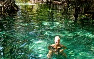
    El Corchito
    comments powered by Disqus
    Xcambó
    '+'

    '+'

    '+'
    '+''; infowindow = new google.maps.InfoWindow({content: contentString}); $(".btnlocation").click(function(){ showMyPosition(); }); $("#pinsdebusquedaclose").click( function(event){ event.preventDefault(); $("#pinsdebusquedaclose").hide(); $("#pinsdeseccion").show(); $("#pinsdebusqueda").hide(); searchingpins=false; showhide(); } ); $("#frmMaps").submit(function(){ if(searchingpins==false){ var tags = $("#frmMaps .txtbuscar").val(); if(tags==''){ // escriba el termino de busqueda }else{ if(ultimabusqueda != tags){ $("#pinsdebusquedaresults").html(""); $("#pinsdebusquedaclose").show(); $("#pinsdeseccion").hide(); $("#pinsdebusqueda").show(); $("#pinsdebusquedawait").show(); $.post("buscarmarcadores.php",{tags:tags},function(data){ $("#pinsdebusquedawait").hide(); $("#pinsdebusquedaresults").html(data); searchingpins=false; showhide(); }); searchingpins=true; }else{ $("#pinsdebusquedaclose").show(); $("#pinsdeseccion").hide(); $("#pinsdebusqueda").show(); } ultimabusqueda = tags; } } return false; }); showhide(); } /** * Data for the markers consisting of a name, a LatLng and a zIndex for * the order in which these markers should display on top of each * other. */ function showhide(){ for(i in allmarkers) { allmarkers[i].setMap(null); } allmarkers = null; allmarkers = Array(); // show checked Markers if( $('#pinsdebusqueda').is(":visible") ){ selector = 'pinsdebusqueda'; }else{ selector = 'pinsdeseccion'; } var current=''; var enabled=''; var markercollection = Array(); var pin = Array(); $('#'+selector+' .markeritem').each(function(i,item){ current = $(this); enabled = current.is(':checked'); if( enabled ){ pin = []; pin.push( current.attr('data-title') ); pin.push( current.attr('data-lat') ); pin.push( current.attr('data-lng') ); pin.push( current.attr('data-icon') ); pin.push( current.attr('data-anim') ); markercollection.push( pin ); } }); setMarkers(map, markercollection, 'images/icons/marker.png'); } function setMarkers(map, locations, markerimage) { // Add markers to the map // Marker sizes are expressed as a Size of X,Y // where the origin of the image (0,0) is located // in the top left of the image. // Origins, anchor positions and coordinates of the marker // increase in the X direction to the right and in // the Y direction down. var imagesize = new google.maps.Size(45, 64); var imageorigin = new google.maps.Point(0,0); var imageanchor = new google.maps.Point(22, 64); var image = { url: markerimage, // This marker is 20 pixels wide by 32 pixels tall. size: imagesize, // The origin for this image is 0,0 origin: imageorigin, // The anchor for this image is the base of the flagpole at 0,32. anchor: imageanchor }; var shadow = { url: markerimage, // The shadow image is larger in the horizontal dimension // while the position and offset are the same as for the main image. size: new google.maps.Size(45, 64), origin: new google.maps.Point(0,0), anchor: new google.maps.Point(0, 64) }; // Shapes define the clickable region of the icon. // The type defines an HTML <area> element 'poly' which // traces out a polygon as a series of X,Y points. The final // coordinate closes the poly by connecting to the first // coordinate. var shape = { coord: [1, 1, 1, 50, 40, 50, 40 , 1], type: 'poly' }; var lastimgsrc=''; for (var i = 0; i '+'
    '+'
    '+'

    '+'

    '+myloc[0]+'

    '+'
    '+''; google.maps.event.addListener(marker, 'click', function() { infowindow.setContent(this.html); infowindow.open(map, this); }); allmarkers.push(marker); } } function showMyPosition(){ // Try HTML5 geolocation if(navigator.geolocation) { navigator.geolocation.getCurrentPosition(function(position) { var pos = new google.maps.LatLng(position.coords.latitude, position.coords.longitude); var infowindow = new google.maps.InfoWindow({map: map,position: pos,content: 'Tu posición actual'}); map.setCenter(pos); }, function() { handleNoGeolocation(true); }); } else { // Browser doesn't support Geolocation handleNoGeolocation(false); } } function handleNoGeolocation(errorFlag) { if (errorFlag) { var content = 'Error: Servicio de Geolocalizacion no disponible.'; } else { var content = 'Error: Tu navegador no es compatible con geolocalizacion.'; } var options = {map: map,position:new google.maps.LatLng(60, 105),content:content}; var infowindow = new google.maps.InfoWindow(options); map.setCenter(options.position); } // The function to trigger the marker click, 'id' is the reference index to the 'markers' array. var lastmarker=null; function showInfo(lat,lng){ pos=-1; if(lastmarker!=null){ allmarkers[lastmarker].setAnimation(null); } $('#'+selector+' .markeritem').each(function(i,item){ current = $(this); if( current.is(':checked') ){ pos++; } if( lat == current.attr('data-lat') && lng == current.attr('data-lng')){ lastmarker=pos; google.maps.event.trigger(allmarkers[pos], 'click'); allmarkers[pos].setAnimation(google.maps.Animation.BOUNCE); return false; } }); } google.maps.event.addDomListener(window, 'load', initialize);

    Mapa

    ¿Donde estoy?
    [+]
    [+]
    [+]
    [+]
    Ver mapa en pantalla completa Ver mapa en pantalla completa

    Mas sugerencias