Dzibilnocac
This is an example of a HTML caption with a link.

Artículos mas leídos

    Dzibilnocac

    La Bóveda Pintada

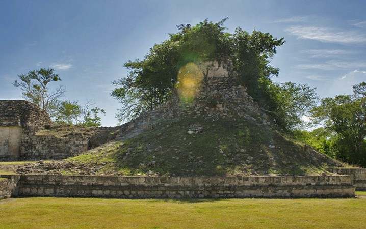
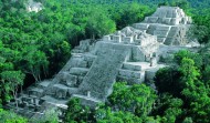
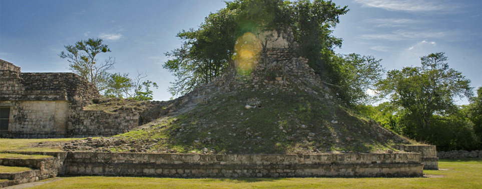
    Asentamiento maya conformado por varios grupos de estructuras, visitar Dzibilnocac te permitirá constatar la majestuosidad de la arquitectura y cultura de los Chenes mayas, lo que hoy en día es el estado de Campeche.

    La ciudad maya se extiende en una superficie de 1.32 kilómetros cuadrados, donde se pueden encontrar edificaciones construidas en el periodo conocido como Clásico Tardío, como lo son pirámides, plataformas, edificios abovedados y habitaciones en todo la extensión.

    Mas información

    Dzibilnocac nombre que en lengua maya significa Bóveda Pintada o Gran Tortuga Pintada. Es un sitio donde las edificaciones son muestra de las primeras evidencias de civilizaciones humanas durante el año 500 al 50 a.C que tuvo su apogeo en periodo Clásico tardío.

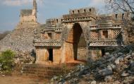
    El sitio fue descubierto en el año 1842, sin embargo la mayoría de las edificaciones aún permanecen sin explorar. El único sitio explorado abierto para los visitantes, es el edificio A, que posee habitaciones ubicadas a lo largo y ancho de esta y tres torres con grabados de templos en las cimas. La estructura es conocida como el Templo-Palacio, su construcción fue realiza entre los años 600 a 800 d.C en el mismo periodo mencionado anteriormente. Conformada por una plataforma de aproximadamente 76 metros de largo y 30 de ancho, en ellas se soportan las tres torres con estilo Río Bec, que se conjugan con cuartos abovedados donde se hace reverencia al Monstruo de la Tierra en los decorados y al Dios maya de la lluvia Chaac en sus esquinas.

    Ubicación y Actividades

    Municipio de Hopelchén.,Campeche. Sitio arqueológico.

    Precio

    Gratuito.

    Como llegar

    A 145 kilómetros al oriente de la ciudad de Campeche. Municipio de Hopelchén. Campeche.

    Horarios

    Lunes a domingo de 8:00 a.m. a 17:00 p.m. 

    Recomendaciones e Información

    Es recomendable llevar ropa ligera y zapatos cómodos que te permita caminar y acceder fácilmente a las distintas áreas del sitio arqueológico ya que el recorrido es a pie, aun que también se puede realizar por medio de bicicletas. Está permitido subirse a las pirámides. También es importante o recomendable llevar repelente de insectos, ya que en el sitio hay una gran cantidad de mosquitos, pues se encuentra enclavada entre exuberante vegetacióny por ende hay muchos y molestosos insectos, Se recomienda también no introducir alimentos ni bebidas. También se aconseja no tomar fotografías con flash. Antes de llegar infórmate sobre las condiciones del clima y elija el mejor momento. Recuerda que es importante respetar y mantener limpio el espacio que estás visitando.

    Servicios

    Teléfono satelital, señalización restrictiva e informativa y señalética explicativa. En esta zona arqueológica se disponen de los siguientes servicios: estacionamiento, unidad de servicios, venta de publicaciones, sanitarios y custodio.

    Sitios Cercanos de Interés

    • CALAKMUL
    • EDZNÁ
    • BALAMKÚ
    • BECÁN
    • CHICANNÁ
    • DZIBILNOCAC
    • EL TIGRE
    • HOCHOB
    • KANKÍ
    • RÍO BEC
    • SANTA ROSA XTAMPAK
    • TABASQUEÑO
    • XCALUMKÍN
    • XPUHIL

    Sitio Web

    http://www.campeche.travel

    Email

    Encargada de Operación de Zonas Arqueológicas Irma Cantún Mata
    Correo electrónico: [email protected]
    comments powered by Disqus
    Dzibilnocac
    '+'

    '+'

    '+'
    '+''; infowindow = new google.maps.InfoWindow({content: contentString}); $(".btnlocation").click(function(){ showMyPosition(); }); $("#pinsdebusquedaclose").click( function(event){ event.preventDefault(); $("#pinsdebusquedaclose").hide(); $("#pinsdeseccion").show(); $("#pinsdebusqueda").hide(); searchingpins=false; showhide(); } ); $("#frmMaps").submit(function(){ if(searchingpins==false){ var tags = $("#frmMaps .txtbuscar").val(); if(tags==''){ // escriba el termino de busqueda }else{ if(ultimabusqueda != tags){ $("#pinsdebusquedaresults").html(""); $("#pinsdebusquedaclose").show(); $("#pinsdeseccion").hide(); $("#pinsdebusqueda").show(); $("#pinsdebusquedawait").show(); $.post("buscarmarcadores.php",{tags:tags},function(data){ $("#pinsdebusquedawait").hide(); $("#pinsdebusquedaresults").html(data); searchingpins=false; showhide(); }); searchingpins=true; }else{ $("#pinsdebusquedaclose").show(); $("#pinsdeseccion").hide(); $("#pinsdebusqueda").show(); } ultimabusqueda = tags; } } return false; }); showhide(); } /** * Data for the markers consisting of a name, a LatLng and a zIndex for * the order in which these markers should display on top of each * other. */ function showhide(){ for(i in allmarkers) { allmarkers[i].setMap(null); } allmarkers = null; allmarkers = Array(); // show checked Markers if( $('#pinsdebusqueda').is(":visible") ){ selector = 'pinsdebusqueda'; }else{ selector = 'pinsdeseccion'; } var current=''; var enabled=''; var markercollection = Array(); var pin = Array(); $('#'+selector+' .markeritem').each(function(i,item){ current = $(this); enabled = current.is(':checked'); if( enabled ){ pin = []; pin.push( current.attr('data-title') ); pin.push( current.attr('data-lat') ); pin.push( current.attr('data-lng') ); pin.push( current.attr('data-icon') ); pin.push( current.attr('data-anim') ); markercollection.push( pin ); } }); setMarkers(map, markercollection, 'images/icons/marker.png'); } function setMarkers(map, locations, markerimage) { // Add markers to the map // Marker sizes are expressed as a Size of X,Y // where the origin of the image (0,0) is located // in the top left of the image. // Origins, anchor positions and coordinates of the marker // increase in the X direction to the right and in // the Y direction down. var imagesize = new google.maps.Size(45, 64); var imageorigin = new google.maps.Point(0,0); var imageanchor = new google.maps.Point(22, 64); var image = { url: markerimage, // This marker is 20 pixels wide by 32 pixels tall. size: imagesize, // The origin for this image is 0,0 origin: imageorigin, // The anchor for this image is the base of the flagpole at 0,32. anchor: imageanchor }; var shadow = { url: markerimage, // The shadow image is larger in the horizontal dimension // while the position and offset are the same as for the main image. size: new google.maps.Size(45, 64), origin: new google.maps.Point(0,0), anchor: new google.maps.Point(0, 64) }; // Shapes define the clickable region of the icon. // The type defines an HTML <area> element 'poly' which // traces out a polygon as a series of X,Y points. The final // coordinate closes the poly by connecting to the first // coordinate. var shape = { coord: [1, 1, 1, 50, 40, 50, 40 , 1], type: 'poly' }; var lastimgsrc=''; for (var i = 0; i '+'
    '+'
    '+'

    '+'

    '+myloc[0]+'

    '+'
    '+''; google.maps.event.addListener(marker, 'click', function() { infowindow.setContent(this.html); infowindow.open(map, this); }); allmarkers.push(marker); } } function showMyPosition(){ // Try HTML5 geolocation if(navigator.geolocation) { navigator.geolocation.getCurrentPosition(function(position) { var pos = new google.maps.LatLng(position.coords.latitude, position.coords.longitude); var infowindow = new google.maps.InfoWindow({map: map,position: pos,content: 'Tu posición actual'}); map.setCenter(pos); }, function() { handleNoGeolocation(true); }); } else { // Browser doesn't support Geolocation handleNoGeolocation(false); } } function handleNoGeolocation(errorFlag) { if (errorFlag) { var content = 'Error: Servicio de Geolocalizacion no disponible.'; } else { var content = 'Error: Tu navegador no es compatible con geolocalizacion.'; } var options = {map: map,position:new google.maps.LatLng(60, 105),content:content}; var infowindow = new google.maps.InfoWindow(options); map.setCenter(options.position); } // The function to trigger the marker click, 'id' is the reference index to the 'markers' array. var lastmarker=null; function showInfo(lat,lng){ pos=-1; if(lastmarker!=null){ allmarkers[lastmarker].setAnimation(null); } $('#'+selector+' .markeritem').each(function(i,item){ current = $(this); if( current.is(':checked') ){ pos++; } if( lat == current.attr('data-lat') && lng == current.attr('data-lng')){ lastmarker=pos; google.maps.event.trigger(allmarkers[pos], 'click'); allmarkers[pos].setAnimation(google.maps.Animation.BOUNCE); return false; } }); } google.maps.event.addDomListener(window, 'load', initialize);

    Mapa

    ¿Donde estoy?
    [+]
    [+]
    [+]
    [+]
    Ver mapa en pantalla completa Ver mapa en pantalla completa

    Mas sugerencias