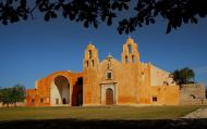
This is an example of a HTML caption with a link.

Artículos mas leídos

    Xcambó

    X´cambó: a hidden world of jungle and archeology

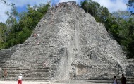
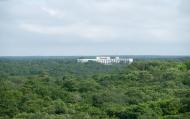
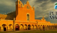
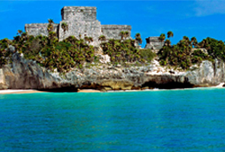
    Xcambó (X'Cambó) is an archaeological site is located in the municipality of Dzemul in the Mexican state of Yucatan. It is considered by experts as one of the most extensive areas in peninsular coast and large buildings. It sits on the wet forest swamp, just 2 kilometers from the coast of the Gulf of Mexico in the north of the peninsula, about 40 km northeast of the city of Merida, the state capital.

    More info

    The Pre-Columbian city of Xcambo has been defined as a port that was important for business development and salt of his time, especially during the early classical period.
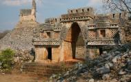
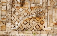
    At the site is a platform called the Temple of the Cross, stepped base with a cross on top. Also another base on top of which is the so-called Temple of Sacrifice and a number of graves were found with the discovery rich offerings in foreign ceramics (polychrome Guatemala and female figurines from Jaina Island).

    Location and activities

    Dzemul.,Yucatan. Archeological site.

    Price

    Entrance fee is 31 pesos (subject to change).

    How to get there

    From Merida: take the 261 highway to Progreso. A little after the track for rowing and canoe racing you'll come to a junction. Turn right and continue on state highway 27 to Telchac Puerto. A little before arriving to Nuevo Yucatan and next to the Laguna Rosada you'll see a turn-off for Xcambo. There's no public transportation to Xcambo.

    Schedule

    Open to the public every day from 8 am to 5 pm.

    Sugestions and Information

    To enjoy your visit to Xcambo to the fullest, follow these recommendations: Bring a hat and sunblock. Climbing the pyramids is permitted. This site is not very busy, so take as many pictures as you want without worrrying about someone walking through your shot. From the Pyramid of the Cross, from which you can see the ocean, you can leave a ribbon or bracelet on the cross on the top. There are no tour guides. Wear comfortable shoes so you can walk around without problems. Check the weather before you go so rain doesn't ruin your visit. Don't forget to respect the area you're visiting and keep it clean.

    Nearest interest places

    El Corchito
    comments powered by Disqus
    Xcambó
    '+'

    '+'

    '+'
    '+''; infowindow = new google.maps.InfoWindow({content: contentString}); $(".btnlocation").click(function(){ showMyPosition(); }); $("#pinsdebusquedaclose").click( function(event){ event.preventDefault(); $("#pinsdebusquedaclose").hide(); $("#pinsdeseccion").show(); $("#pinsdebusqueda").hide(); searchingpins=false; showhide(); } ); $("#frmMaps").submit(function(){ if(searchingpins==false){ var tags = $("#frmMaps .txtbuscar").val(); if(tags==''){ // escriba el termino de busqueda }else{ if(ultimabusqueda != tags){ $("#pinsdebusquedaresults").html(""); $("#pinsdebusquedaclose").show(); $("#pinsdeseccion").hide(); $("#pinsdebusqueda").show(); $("#pinsdebusquedawait").show(); $.post("buscarmarcadores.php",{tags:tags},function(data){ $("#pinsdebusquedawait").hide(); $("#pinsdebusquedaresults").html(data); searchingpins=false; showhide(); }); searchingpins=true; }else{ $("#pinsdebusquedaclose").show(); $("#pinsdeseccion").hide(); $("#pinsdebusqueda").show(); } ultimabusqueda = tags; } } return false; }); showhide(); } /** * Data for the markers consisting of a name, a LatLng and a zIndex for * the order in which these markers should display on top of each * other. */ function showhide(){ for(i in allmarkers) { allmarkers[i].setMap(null); } allmarkers = null; allmarkers = Array(); // show checked Markers if( $('#pinsdebusqueda').is(":visible") ){ selector = 'pinsdebusqueda'; }else{ selector = 'pinsdeseccion'; } var current=''; var enabled=''; var markercollection = Array(); var pin = Array(); $('#'+selector+' .markeritem').each(function(i,item){ current = $(this); enabled = current.is(':checked'); if( enabled ){ pin = []; pin.push( current.attr('data-title') ); pin.push( current.attr('data-lat') ); pin.push( current.attr('data-lng') ); pin.push( current.attr('data-icon') ); pin.push( current.attr('data-anim') ); markercollection.push( pin ); } }); setMarkers(map, markercollection, 'images/icons/marker.png'); } function setMarkers(map, locations, markerimage) { // Add markers to the map // Marker sizes are expressed as a Size of X,Y // where the origin of the image (0,0) is located // in the top left of the image. // Origins, anchor positions and coordinates of the marker // increase in the X direction to the right and in // the Y direction down. var imagesize = new google.maps.Size(45, 64); var imageorigin = new google.maps.Point(0,0); var imageanchor = new google.maps.Point(22, 64); var image = { url: markerimage, // This marker is 20 pixels wide by 32 pixels tall. size: imagesize, // The origin for this image is 0,0 origin: imageorigin, // The anchor for this image is the base of the flagpole at 0,32. anchor: imageanchor }; var shadow = { url: markerimage, // The shadow image is larger in the horizontal dimension // while the position and offset are the same as for the main image. size: new google.maps.Size(45, 64), origin: new google.maps.Point(0,0), anchor: new google.maps.Point(0, 64) }; // Shapes define the clickable region of the icon. // The type defines an HTML <area> element 'poly' which // traces out a polygon as a series of X,Y points. The final // coordinate closes the poly by connecting to the first // coordinate. var shape = { coord: [1, 1, 1, 50, 40, 50, 40 , 1], type: 'poly' }; var lastimgsrc=''; for (var i = 0; i '+'
    '+'
    '+'

    '+'

    '+myloc[0]+'

    '+'
    '+''; google.maps.event.addListener(marker, 'click', function() { infowindow.setContent(this.html); infowindow.open(map, this); }); allmarkers.push(marker); } } function showMyPosition(){ // Try HTML5 geolocation if(navigator.geolocation) { navigator.geolocation.getCurrentPosition(function(position) { var pos = new google.maps.LatLng(position.coords.latitude, position.coords.longitude); var infowindow = new google.maps.InfoWindow({map: map,position: pos,content: 'Your actual location'}); map.setCenter(pos); }, function() { handleNoGeolocation(true); }); } else { // Browser doesn't support Geolocation handleNoGeolocation(false); } } function handleNoGeolocation(errorFlag) { if (errorFlag) { var content = 'Error: Servicio de Geolocalizacion no disponible.'; } else { var content = 'Error: Tu navegador no es compatible con geolocalizacion.'; } var options = {map: map,position:new google.maps.LatLng(60, 105),content:content}; var infowindow = new google.maps.InfoWindow(options); map.setCenter(options.position); } // The function to trigger the marker click, 'id' is the reference index to the 'markers' array. var lastmarker=null; function showInfo(lat,lng){ pos=-1; if(lastmarker!=null){ allmarkers[lastmarker].setAnimation(null); } $('#'+selector+' .markeritem').each(function(i,item){ current = $(this); if( current.is(':checked') ){ pos++; } if( lat == current.attr('data-lat') && lng == current.attr('data-lng')){ lastmarker=pos; google.maps.event.trigger(allmarkers[pos], 'click'); allmarkers[pos].setAnimation(google.maps.Animation.BOUNCE); return false; } }); } google.maps.event.addDomListener(window, 'load', initialize);

    Map

    ¿Donde estoy?
    [+]
    [+]
    [+]
    [+]
    Ver mapa en pantalla completa View map in full screen

    More suggestions