


| Iglesia de San Gervasio, Valladolid, Yucatán |


ArtÃculos mas leÃdos


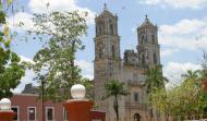

Iglesia de San Gervasio, Valladolid, Yucatán
La única iglesia que no mira hacia Roma y el crimen pasional que cambió su arquitectura
A finales del siglo XVII, fué enviado a la ciudad de Valladolid el señor Fernando Hipólito Osorno, en calidad de capitán general, Osorno, hombre de carácter fuerte y de alta alcurnia en la sociedad española, también era conocido por ser muy enamorado, lo que a la larga serÃa motivo de su muerte. Resulta que el capitán Osorno se involucra con la novia del alferéz mayor de Valladolid, Don Miguel de Ruiz Ayuso, quien sin hacer ruido planea la manera de vengarse de su rival.
Tiempo después por cuestiones polÃticas, Osorno es destituido de su puesto y llevado a la cárcel por diversas acusaciones y, temiendo por su vida, logra escapar se refugia en la Iglesia de San Gervasio donde solicita el asilo del templo.
En el año de 1706, Don Miguel Ruiz Ayuso se convierte en alcalde de Valladolid y Osorno es sacado a la fuerza del recinto sagrado y golpeado hasta morir, acto que para la iglesia católica resultó ser una tremenda profanación.
Tiempo después la fachada del templo se reconstruye como hoy la contemplamos, y para evitar que el nuevo altar tuviera la misma posición en la que fuera agraviada, se le dio una nueva orientación. Por tal motivo la iglesia está dirigida hacia el norte y no al poniente, como la generalidad de los templos yucatecos de la época colonial que miran a Roma.
Ubicación y Actividades


