

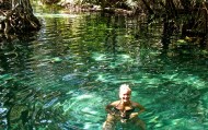


| Cenotes de San Antonio Mulix |
")
This is an example of a HTML caption with a link.
Artículos mas leídos

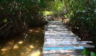


Cenotes de San Antonio Mulix
Ubicada a 49 kilómetros de la ciudad de Mérida, la comunidad de San Antonio Mulix es otro punto que no te debes perder.
Mas información
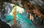
Cuenta con un parador ecoturistico llamado Tumben Zazil Kin Zonot, rodeado de coloridos paisajes. Este destino ofrece dos magníficas áreas de diversión: el cenote X'batún, extraordinario recinto para practicar espeleobuceo o simplemente refrescarse, y el cenote Dzombakal, cuyas aguas de transparente claridad invitan a los viajeros a sumergirse en la naturaleza.
El recorrido se puede hacer en bicicleta, y de hecho es muy recomendable hacerlo de esta manera, para que puedas disfrutar de un excelente paisaje que incluye flora y fauna propias de la región, que te harán relajarte y olvidarte del ajetreo citadino.
El X'batún está en una hondonada rodeada de rocas y plantas. A su alrededor es común escuchar a las aves que bajan a beber, y lirios acuáticos le dan un toque especial al paisaje, donde podrás nadar entre peces de colores cuando te sumerjas en sus aguas.
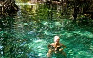
El agua de ambos cenotes es ideal para la época de verano, porque se convierten en refrescantes refugios contra el calor sofocante. En ambas cavernas podrás bucear, nadar y esnorquelear, dejándote llevar por estas místicas aguas, fuente de vida de los antepasados mayas.
El recorrido se puede hacer en bicicleta, y de hecho es muy recomendable hacerlo de esta manera, para que puedas disfrutar de un excelente paisaje que incluye flora y fauna propias de la región, que te harán relajarte y olvidarte del ajetreo citadino.
El X'batún está en una hondonada rodeada de rocas y plantas. A su alrededor es común escuchar a las aves que bajan a beber, y lirios acuáticos le dan un toque especial al paisaje, donde podrás nadar entre peces de colores cuando te sumerjas en sus aguas.
El agua de ambos cenotes es ideal para la época de verano, porque se convierten en refrescantes refugios contra el calor sofocante. En ambas cavernas podrás bucear, nadar y esnorquelear, dejándote llevar por estas místicas aguas, fuente de vida de los antepasados mayas.
Ubicación y Actividades
San Antonio Mulix,Yucatan. Nado, Bicicleta
Como llegar
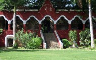
Se encuentra a 49 kilómetros de Mérida, por la carretera Muna-Uxmal, se desvía en el kilómetro 39 a mano derecha, rumbo a la ex hacienda Cacao. Ya cuando llegue a la ex hacienda San Antonio Mulix, ahí usted toma un camino de terracería de 2.3 kilómetros para poder llegar a este cenote. Puede entrar con su vehículo o también tiene la opción de rentar una bicicleta.
Horarios
Hay acceso a los dos cenotes de 9 a 5 de la tarde y en el lugar se pueden rentar cabañas, casas de campaña, bicicletas, equipo para esnorquelear, chalecos salvavidas y servicio de guía.
Recomendaciones e Información
Puedes rentar bicicletas para hacer el recorrido e incluso chalecos
salvavidas para mayor seguridad. Rumbo a los cenotes encontrarás escenas típicas y un restaurante ecológico, cuya energía es alimentada por paneles solares.
salvavidas para mayor seguridad. Rumbo a los cenotes encontrarás escenas típicas y un restaurante ecológico, cuya energía es alimentada por paneles solares.
Servicios
Restaurante, bicicletas, Máscara de snorkel


